
Calcrete-Capped Megaflood Gravel - George, WA
- Skye Cooley
- Sep 7, 2022
- 13 min read
Updated: Jan 22

George gravel pit.

George gravel pit. Location is N of historic Burke, WA and NW of non-historic George, WA.

George is not Burke. My friend Richard Waitt, like Bretz before him, properly refers to the site as Burke, the name of the once bustling hamlet located ~1.5 km south of the pit, along Beverly-Burke Rd. Burke is mentioned in early articles on the Channeled Scablands and has a place in the hearts of Scabland geologists. The placename has graced maps of Washington for many decades. Its storied post office and bright, friendly railstop sign has long welcomed travellers to the Quincy Basin. The town of George, on the other hand, has no history to speak of. George was invented during construction of I-90, its name a joke. Highway department humor. Today, the citizens of Burke just shake their heads, "Its a a dirty shame". George reaped the benefits of the new freeway, while has slowly Burke faded into obscurity. The George gravel pit is properly called 'Burke', but I call it 'George' because I prefer gas station hot dogs to home cooked meals.
Location
George, WA - inferior in every way to Burke - hosts a classic exposure of old flood gravel. Take Exit 149 onto Hwy 281/Quincy/Wenatchee. Turn west onto Hwy 281 and cross over the freeway. Follow Hwy 281 a short distance then turn L onto Beverly-Burke Rd, then R onto Rd 1 NW. A square green metal-sided building with a small parking lot is your destination: The George Landfill, which at some point in the past was called the George Drop Box, is mostly abandoned, a property of Grant County Public Works (office in Ephrata). Please respect any signage they have posted. I've not had any issues accessing the pit. Exposures are along the east and south walls. GPS: 47.10041, -119.87017.
Previous Work
Vic Baker and George Neff (Baker, 1973), following Bretz et al. (1956) and Richmond et al. (1965), described the George deposit as "pre-Bull Lake flood gravels" mostly because of the thick cap of calcrete, a paleosol of considerable age. Richard Waitt refers to this site as "Burke", which is the nearest rail station. Calcrete this thick requires hundreds of thousands of years to form. Bull Lake is a somewhat antiquated term that refers to the penultimate glacial episode preserved in the central Rocky Mountains. The Last Glacial Period is known there as the Pinedale glaciation. We call the Pinedale the Fraser in Washington and BC. The Pacific Northwest sorely needs to formalize its own glacial-period terminology. Its high time we distinguish our record from that of the Rocky Mountains. "Fraser" is start, but the name just seems too Canadian for many American geologists to embrace. Me included. How about "Northwest glaciation" or "Pacific glaciation"?

Baker's figure. According to Baker (1973), the George gravels were recognized by Richmond et al. (1965) as "pre-Bull Lake flood gravel" capped by "platy caliche". The Pinedale glaciation (Rocky Mountains) is the Fraser glaciation (Pacific Northwest). Bull Lake glaciation is older and has largely been replaced by terms like "pre-Wisconsin". Bretz called the older glaciation in his 1928 map of the scablands the "Spokane" glaciation.
The Gravels
The east and south walls of the pit expose >4m of old flood gravels (pebble-cobble-boulder) with southeast-dipping foresets capped by a meter-thick, blocky to platy, fully-plugged calcrete (> Stage III). The bouldery gravel contains weathered and unweathered basalt clasts, some light-colored granite, minor quartzite, and a few chunks of Vantage sandstone (a interbed in the basalt). Crumbly green-white-yellow-gray opal comes from rusty pillow-palagonite complexes in the basalt. A few compact, unfractured chunks of opal suitable for flintknapping projectile points can be found; look for the light gray stuff.
Paleo-water table
It is unlikely the elevation of the George site has changed much over the past few million years. The basalts in the area are flat lying and unwarped by Yakima Fold Belt structures. There is no evidence of broad-scale rise of the basalt surface and the Ice Age floods did not scour deeply into bedrock. The tilt on the Palouse Slope is minimal here. The local water table is likely higher today than it was in the Pleistocene due to irrigation canals that artificially elevate it. I see some evidence of groundwater table in the gravels, but the pile doesn't look like its been stewing in its own juices (saturated) for hundreds of thousands of years.

Easy access. The gravel pit at George is an inactive and easily accessible quarry located a few steps from the pavement. The pit was first described by geologists many decades ago, but few details, photos, or sketches are found in their notes.

Meter-thick calcrete. Roughly a meter of calcrete caps the exposure and overprints coarse the flood gravels. This calcic paleosol (petrocalcic horizon) occurs throughout the region as a blanket-like unit. Thick calcretes in south-central Washington are actually composed of several soils, some welded.
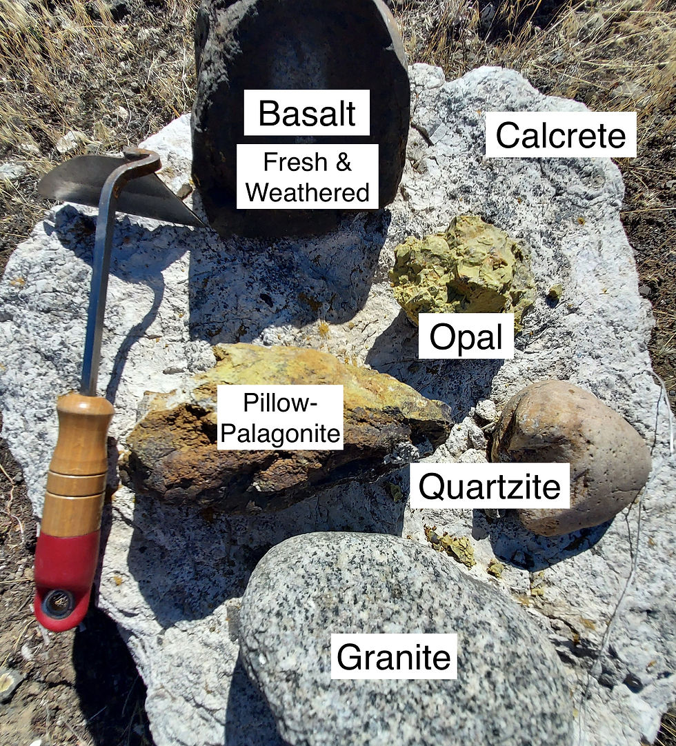
Exotic and mundane. Clasts of fresh Miocene Columbia River Basalt and associated chunks of green-yellow opal and rusty palagonite (derived from local pillow basalt complexes) are the dominant lithologies found in the gravels at George. Exotic lithologies include granite and minor quartzite in cobble sizes. Deeply-weathered clasts of basalt are also common.
How Many Floods?
Many believe there is more than one flood represented here, but a distinct sedimentological break between floods is difficult to tease out. A few meters below the calcrete ledge is a thinner, discontinuous, yet conspicuous second calcrete horizon (~15cm thick). It parallels the ledge in places and follows foresets in others, suggesting it is not a paleosol, but represents a somewhat complicated pathway followed for a time by groundwater. I struggled to find throughgoing erosional surfaces, fining-upward relationships, or other distinct breaks in the gravel pile. Let me know what you find.
Colossal Conspiracy! Monstrous Maleficence!
I urge caution when interpreting the age of gravels containing weathered clasts. Early floods through the Channeled Scablands almost certainly encountered not only loess-covered hills, but broad swaths of deeply-weathered basalt - a fractured, crumbling zone a meter or more thick. Floods also transected fairways of non-basaltic material left behind by ancient streams that may itself been fresh or weathered. The rushing floods entrained everything in their path and deposited it along the floodway in sheets and bars. Fragile weathered basalt, like fragile mudstones from the Ringold or fragile sandstones from local interbeds, do in fact survive some amount of transport. To my eye, the presence of weathered clasts in a calcrete-capped megaflood gravel might indicate the deposit is very old, but its possible that some of the weathering occurred well before the floods arrived.
Check out my recent YouTube video where I find weathered and unweathered clasts at George:
Watch video. Check out this YouTube video where I explore weathered and seemingly unweathered clasts at George.
Competing Hypotheses on the Origin of Deeply Weathered Basalt
Either the deeply weathered basalt clasts in pre-Wisconsin deposit at George are:
a.) Weathering then Transport. Rip-ups of previously-weathered material dislodged from grungy bedrock footings by overland floods.
b.) Transport then Weathering. Fresh clasts were deposited by floodwaters and the gravel pile weathered in place over a long period.
The first option infers the period of weathering occurred during the late Miocene and Pliocene (weathered bedrock). The second, preposes all weathering took place during the Pleistocene (weathered gravel). So how to determine which is correct? A few things come to mind...

Corestones. A corestone forms as fractured bedrock degrades. The weathering front moves from the top down and from fractures outward. Here the weathered zone is several meters thick. The rind appears mostly composed of degraded primary minerals (magmatic) and not many clay minerals (alteration). Clay minerals may take longer to grow than the period the rock has been subjected to weathering.

Relative stability. Different minerals have different stabilities at the Earth's surface, therefore weather at different rates. This figure by Colman (1982) shows the relative stabilities of minerals in basalts and andesites. Glass and olivine weather first. Plagioclase and pyroxene are next. Last are the stable opaque minerals (i.e., magnetite). The relative mobility of elements in basaltic weathering rinds is Ca > Na > Mg > Si > Al > K > Fe > Ti.
a.) Examine spoil piles. Quincy Chute is a large feeder canal in the Columbia Basin Irrigation system. It crosses White Trail Rd/Rd 5 SW just west of the Colockum Golf Course. Voluminous spoil piles left by the dredge that created it contain abundant weathered basalt, calcrete, and unweathered basalt. The canal is >5 meters deep, excavated into bedrock and below the scabland surface. Its bottom lies in Miocene material, well below any surficial deposits left behind by floods. Much of the dredged material was in situ prior to canal construction - you can see horizontal strata in the walls of the canal near the parking lot. This indicates at least some near-surface basalt was weathered, that the weathered zone was fairly thick, and that the entire weathered zone was not completely scoured away by the overland floods.
b.) Examine well logs. Well logs are available free online through the Washington Department of Ecology. Driller's notes, while notoriously generalized, do a pretty good job of noting weathered basalt. Logs of wells near George are replete with descriptions of "soft", "decomposed", "broken", and "decayed" basalt. For the most part, floodwaters moving through Quincy Basin were not deeply erosive, so a thick zone of weathered regolith remains, if buried beneath younger flood deposits.

Dredged spoils. Investigate the material dredged from irrigation canals in order to see what's below the scabland surface. Have members of your group each pick out 3-4 samples that show different expressions of weathering. Examine the degree of rounding, too. Reconvene and sort what's been gathered into piles. What explains the variation? When in the life of the clast did rounding occur? Photo location is Quincy Chute Hydroelectric Plant off White Trail Rd (Rd 5 SW) near Colockum Golf Course.

Quincy Chute spoils pile. Dredged spoils pile is seen in distance. Access the pile from the backside (east facing exposures) via an old road out of frame to the left. Stay well away from the pump equipment, canal, and the access gate. Look for a simple gate in sagebrush west of the secured entrance or call the Watermaster about access. No need to trespass on the facility. I park in the orchard across the road.

Quincy Basin rhythmites. Last-glacial Missoula Flood rhythmites in the Quincy Basin were deposited as broad, fan-like, sandy sheets. They are thin and locally oxidized by the modern groundwater table. You could call these a distal facies of more energetic channels that spilled out of the Columbia Valley or exited Lower Grand Coulee. East of Quincy, flood deposits become bouldery (i.e., junction of Hwy 28 and Hwy 283). South of Ephrata the boulders get really big and numerous (Ephrata Fan). Photo location is a canal cut south of Winchester, WA. Geologic maps incorrectly show these canals as strips of Ringold Fm.
c.) Examine outcrops. If the basalt clasts in a pre-Wisconsin flood gravel weathered together after deposition, then wouldn't many, if not most, bedrock knobs and buttes that never saw flooding (areas above flood trimlines) show similar depth of weathering? I don't see that. In fact, spheroidal weathering in the stack of CRB flows is hit and miss. The same flow in one location may be deeply weathered, but elsewhere appear fresh. In high cliffs where numerous flows can be seen, is weathering systematically greater in the older flows? I don't see that either.
d.) Investigate unweathered clasts. A small percentage (1%) of hard, fresh, and apparently unweathered basalt clasts occur in amongst the weathered clasts (99%). They are admittedly few in number, but their presence raises the possibility that all of the weathering may not have occurred after deposition. If that were the case - fresh clasts deposited and weathered after deposition - then none of the clasts should be fresh. The whole pile should be equally weathered and one clast should look like the next. However, vesicular clasts in all size fractions tend not to be thoroughly weathered. In fact, many appear unweathered. Most are quite hard, have no reddish hue, and lack fractures. A few other ringing-hard clasts of typical aphanitic basalt can also be found in the outcrop. Does vesicular basalt resist weathering or weather at a different rate than non-vesicular basalt? How might we explain the presence of a few hard, fresh non-vesicular basalt clasts in the pile? Did the ancient flood that deposited the gravel at George liberate both partially-weathered basalt (regolith) as well as unweathered basalt? Does the calcrete indicate the gravels were saturated during the Pleistocene - below the water table, weathering more quickly than dry gravels would?
e.) Variety. Weathered clasts at George do not all look the same. Considerable variety exists. Flood-quarried basalts do not appear uniformly weathered. Clasts may originate from different basalt flows and/or different depths below the ground surface.
f.) Corestones. Another observation, perhaps related, is pre-rounded core stones present in nearby outcrops. Roadcuts along Hwy 262 west of Hwy 17 just upstream of Drumheller Channels contain "boulders" (corestones) that are still attached to large columns. Downstream, boulders liberated by the floods are found. Rounding of some was not produced by tumbling along in a flood. Rather, in situ weathering did it.

Pre-weathered corestones. North flank of Saddle Mountains a mile east of Sentinel Peak and 800 feet above the Crab Creek Valley.

Pre-weathered corestones. Hwy 262 roadcut just upstream of Drumheller Channels.

Pre-weathered corestones. Lind Coulee at O'Sullivan Reservoir.

Vesicular clasts weather differently? Weathered and less-weathered vesicular clasts occur together in the pile.
Sandy Silts
Discontinuous lenses of reddish, silty-sandy sediment that contain abundant cemented root casts and burrows occur with the gravel just below the capping calcrete. Identical sediments are commonly associated a several flood deposit localities in the Othello-Saddle Mts-Paradise Flats area and appear to be a fine grained flood facies that attracted plants and burrowing critters later.
Calcretes Are Lowland Deposits
One of the most important, but least emphasized, aspects of calcretes in this part of Eastern Washington is their formation in lowland settings. Thick calcretes are closely associated with alluvial bottomland sediments, low-gradient alluvial fans, and sometimes ancient megaflood deposits. They developed near the paleo-water table, likely within the capillary fringe. People have written thoroughly on thinner, less distinctive caliche horizons in Palouse loess, but those are child's play. West of the Palouse, calcretes thicken considerably, becoming blanket-like layers that constitute a mappable, correlatable zone with regional extent. The calcretes are not a subunit of the upper Ringold, a commonly held belief of mapping crews in past decades (i.e., Grolier and Bingham, 1978). The so-called "capping calcretes" that today reside atop Yakima Fold Belt ridges formed in low-elevation, low-relief valley bottoms and low-angle alluvial fans. Later, they were elevated by faulting (Cooley, 2022 - email me for a copy).

Columbia Embayment. A structural low called the Columbia Embayment formed during the tail end of the Mesozoic in accreted lying rocks outboard of the Precambrian margin (red dashed line is the 0.706 Sr line). However, the crustal embayment correspnds with a large indentation (a bay) in the former edge of the continent, which means it may be much older. Its original shape has probably been modified by northward out-migration of terranes (i.e., Baja-BC), Basin and Range extension, post-Micoene clockwise rotation, and growth of the Yakima Folds. The important thing is that a broad crustal low has existed here since the late Cretaceous if not earlier. Figure from Tikoff et al. (2022, Fig. 7).

Flood basalts fill structural lows. Wanapum and Saddle Mountains Basalts filled structural-topographic low spots in the Miocene landscape. Map from Camp (2017, Figure 4 excerpt).

Is Othello the center of the known universe? Othello sits near the center of the Wanapum Basalt, the center of the Columbia Plateau aquifer, and the center of Neogene basin-fill sediments that overlie the basalt. Its been a low spot since at least the Miocene, attracting flood basalts, several major rivers, and the Missoula floods. Calcretes are thickest in the northern Pasco Basin, just south of Othello.
Calcrete Type Sections West of the Palouse
The literature on the Palouse loess associates caliche/calcrete with upland hillslopes composed of windblown silt (see papers by Busacca and McDonald 1988-2012). Field relationships in the broader region, however, reveal thick calcrete is more closely associated with floodplain deposits and gently-sloping alluvial fans. Calcrete is more fully developed in basins west of the Palouse and are far more interpretable there. Calcretes thin to the east, becomming more numerous and increasingly discontinuous as elevation, rainfall, and sedimentation rates increase. Type sections for Eastern Washington's calcretes are best found at Othello, Saddle Mountains, and White Bluffs (Pasco Basin). The few advanced-stage, pre-Wisconsin calcretes that occur in loess are typically low in the Palouse section ("early Palouse soil") near the contact with basalt. They may mark periodic eastward incursions of basinal conditions (climate, groundwater, sedimentation rate) onto the Palouse Slope prior to tectonic wrinkling and development of topographic relief there (late Pliocene to early Pleistocene).
Ancient Scabland Floods From Both East and West?
Floodwater that deposited the gravel at George flowed south down an ice-free Columbia River gorge (or Moses Coulee?), exited west into Quincy Basin near Babcock Ridge, and moved inland toward Drumheller Channels. Gravels and calcretes at White Trail (Cooley, 2022, Stops 3 and 4), Frenchman Hills Wasteway (George Neff's "Winchester" site in Baker, 1973), and Herman Railcut (Cooley, 2022, Stop 12) are likely correlative. This early route through Drumheller Channels contrasts with that of early flooding (and calcrete-capped gravels) in the eastern Scabland (SE of Ritzville) - at Harder Road and Marengo railcut (Baker et al., 1991). Evidence for at least one early flood is preserved there in the Telford tract. Floodwater escaped the Columbia near Spokane, moved south through loess hills toward paleo-Washtucna Coulee, and diverted west to scour the lower Eagle Lake surface, Esquatzel Coulee, and Ringold Coulee. Both flood routes appear to converge at a regional sag at modern day Othello. Drumheller Channels (Crab Creek), Lind Coulee (Crab Creek) appear to be long-lived, pre-scabland troughs (Pliocene alluvial valleys). It remains unclear how the timing of ancient flooding in the western Scabland (George, White Trail, Winchester) and eastern Scabland (Harder, Marengo) relate. Also unclear is their relation to paleosol-capped gravels in Pasco Basin to the south (White Bluffs Overlook, Old Maid Coulee).

Routes taken by the earliest scabland floods? Calcrete-capped flood gravels occur in eastern and western portions of the Channeled Scablands (blue areas). A single floodpath cannot explain gravel occurrence in both places if our understanding of an ice-blocked Columbia is correct. Ancient floods appear to have converged on a regional low at Othello (between the two arrowheads). Calcretes are thickest there, too. The Othello area has been a structural-topographic low spot since at least the Pliocene. Basemap is from Bretz (1932). Floodwater continued south along the mainstem Columbia channel past Quincy Basin and into the Pasco Basin, but I've not shown that here.

Both the same. These two clasts are weathered to the same degree.

Fractures and fronts. Fractured and crumbling clasts of weathered basalt come apart in your hand with just a squeeze. Through-going fractures, onion skin-like rinds, colorful concentric patterns around corestones, crumbling textures, and a reddish hue are all signs of weathering. Note there is some variety in the expression of weathering, possibly reflecting differences in weathering duration or intensity (weathering histories) for the clasts or the bedrock from which they were derived.

Silty-sandy lenses. Discontinuous lenses of reddish, silty-sandy sediment containing abundant root casts and cemented burrows occur just below the capping calcrete. Grainsize would suggest these are not flood deposits, but represent a post-flood loess bed or a proximal eolian sand sheet (proximal loess facies; reworked flood deposits). However, these sediments are commonly associated with flood sediments and occur in the same stratigraphic position as flood gravels. Here, it lies directly atop dark colored flood gravel and contains many rounded clasts.

Calcrete ribbons. Ribbons of CaCO3 with the right morphology suggest throughflow, inflation (vertical expansion due to mineral growth), and a larger proportion of fine grained sediment. Note how secondary carbonate scaffolds on the gravel (parent material) and envelopes it. Fewer clasts are seen the higher you go in the calcrete unit, but many are still there, completely coated. Also, this section may be slightly thicker than it was when first deposited due to the inflative effects of carbonate growth.
You comments are always welcome: skyecooley@gmail.com
................................
References
Baker, 1973, GSA Special Paper 144
Baker et al., 1991, Decade of North American Geology v.2 - Quaternary Non-glacial Geology, p. 215-250
Bretz, Smith, and Neff, 1956, GSA Bulletin v. 67
Colman, 1982, Chemical weathering of basalts and andesites: Evidence from weathering rinds, USGS Professional Paper 1246
Cooley, S.W., 2022, Calcrete in the Channeled Scablands, Yakima Fold Belt, and Palouse Hills, NORTHWEST GEOLOGY - Journal of the Tobacco Root Geological Society 47th Annual Field Conference and Guidebook (Wenatchee, WA), v. 51, p. 49-75
Grolier and Bingham, 1978, Washington DGER Bulletin 71


